Log in
All resources
Create a design
25 Free Images of Northern Sea Route
old maps of the white sea
maps of the barents sea
latin-language maps
dutch-language maps
baptista van doetecum
maps of novaya zemlya
1590s maps of norway
1590s maps of sweden
1590s maps of denmark
whales on maps
third voyage of willem barentsz
16th-century maps of the arctic
third voyage of willem barentsz
history of dutch sea fisheries
third voyage of willem barentsz
history of dutch sea fisheries
third voyage of willem barentsz
16th-century maps of the arctic
third voyage of willem barentsz
16th-century maps of the arctic
the voyage of the vega round asia and europe
third voyage of willem barentsz
overwintering on nova zembla by willem barentsz, 1596-1597
maps in the rijksmuseum amsterdam
overwintering on nova zembla by willem barentsz, 1596-1597
maps in the rijksmuseum amsterdam
itinerario (jan huygen van linschoten)
latin-language maps
landscape
water
itinerario (jan huygen van linschoten)
latin-language maps
landscape
travel
itinerario (jan huygen van linschoten)
latin-language maps
old constellation maps
maps by samuel dunn
maps of novaya zemlya
india orientalis
landscape
travel
maps of novaya zemlya
1590s maps
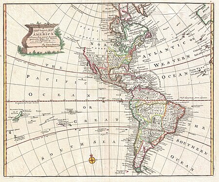
18th-century maps of north america
1708 maps of north america
18th-century maps of the malay archipelago
18th-century maps of southeast asia
paintings by bonaventura peeters (i) in the national maritime museum, london
flemish baroque painting
alabama (ship, 1862)
samuel walters
1740s maps of the americas
1747 maps of north america
maps by john cary
1801 maps
1690s maps of the caribbean
1690s maps of the americas
carte des côtes de malabar et de coromandel (1723)
philippe buache
1 - 25 of 25
/ 1